|
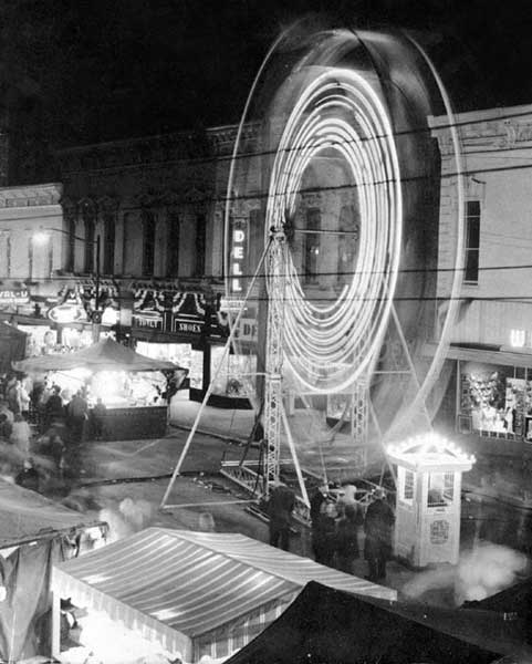
A scene from Columbus Indiana Past: Washington St. blocked off to accommodate a carnival in 1953
|
Columbus Indiana Pictures and Photos From Bygone Days
These photos and pictures highlight what Columbus Indiana looked like before the McDonalds, Wal-Marts, and Blockbusters of today. It was a time when people did their shopping downtown and everyone still complained about finding a place to park. During the time many of these pictures and photographs were taken, Washington Street seemed forever busy with people and traffic. People actually parked their cars and walked from store to store and didn't mind. Specialty shops were in their heyday in some of the photos, and on the decline in others. Dell Brothers, G. C. Murphy's 5 & 10, Edwards Department Store, the Dollar Store, Cummins Bookstore, Nagel's Bookstore, the White House Department Store, Carpenters Drugs, H. L. Rost Jewelers, Palms Cafe, the White Star meat market, Carpenters Drugs, Dalton & Payne, and many other stores offered the shopping public almost anything they wanted and needed, and the history of Columbus Indiana downtown businesses is reflected here within these pictures. If you wanted a hamburger, you went to Frisch's or Lucas Brothers or the Red Barn. G C Murphy 5 & 10 was the "Wal-Mart" of this time and if you wanted to rent a movie? Well, who ever dreamt of being able to do such a thing in the late 1950's/early 1960's?! This collection represents our community heritage, and does a wonderful job of keeping that part of our legacy alive... I would like to thank the following people for making these pictures available: Richard Bray, Joy Deckard, John Rondot, Jane Dunham, Stan Franke, Sonny Barnhart, Norman G. Morris, Bob Welmer, Pam Cordry, and Joan Weinantz. If I have forgotten anyone, I apologize for the oversight...
Click on any thumbnail image for a better view If you have any pictures of Columbus you would like to see added, please email me This Page is Best Viewed Using Internet Explorer, and at 800 x 600
|
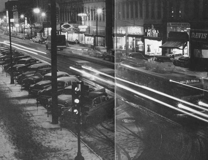
Downtown Columbus Indiana at night, 1955
|
| About
The Historic Columbus Indiana Website
Bartholomew County Directory 1903 -- 1904 Columbus Indiana: A Day In The Life... Columbus Indiana City Directory Columbus Indiana: Downtown Pictures 1966 Columbus Indiana Picture Collections Columbus Indiana Historic Postcards Columbus High School Yearbooks and Logs 1916 --1970 Historic Columbus Indiana Site Map Historic Columbus Indiana Welcome Page I Discover Columbus, by Will Marsh Illustrated Columbus Indiana 1914 -- 1915 Links to other Columbus Indiana-related sites Old Historic Columbus Indiana Website What Columbus Indiana Watched on Television
|
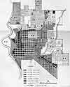
I can't think of a better way to start off this page than offering a map of what Columbus Indiana looked like in 1949. This map is a LARGE file, coming in a little over .7MB, so if you have a dial up connection to the internet, it will take some time to upload it. In 1905, Columbus Indiana city boundaries extended from Mulberry Street (what we now call 1st Street), to 21st Street (which was only about 3 blocks, running between Central and Elm. 16th Street was the major dividing line separating the city from the country). These north to south boundaries included many street names we are unfamiliar with today. Lafayette Street was known as Mechanics, and was changed sometime during WWI. 3rd Street was known as Tipton. 4th Street was Walnut. Almost all of the east-west streets in the city were named after presidents or local residents. 9th Street was Irwin, and 12th Street was called Stansifer. The numbered, east-west streets came into existence sometime in the 1880's. 1905 north-south streets began at the river (Jackson street ran from 1st to 11th), to Central Avenue (see map of Columbus on the I Discover Columbus page). By 1949, Columbus Indiana had grown considerably, and now included parts of East Columbus. "Maple" Street, which was in East Columbus, was Mapleton by the time we moved to Center Street in 1954. When the name was changed is unknown. There was no "Central Avenue" from 10th Street south to 3rd (what we now call Central). During my years growing up here, when built, it was known as Hawcreek Boulevard. Central ran from 10th Street to 25th Street. One of the things this 1949 map points out is the railroads that played an important and much overlooked role in the history of Columbus. People used to joke that, if the police wanted to thwart a bank robbery, just park boxcars on all the rail intersections throughout Columbus streets. The decline of the importance of railroads in Columbus can be seen by comparing this map to any current map of Columbus. The major railroad arteries still exist, but many of the sidetracks which once ran through the city are now gone. This map appeared in the "Regulations for Zoning, Building, Subdivision Control, and Plat Approval" booklet, issued by the city of Columbus Indiana in 1949. I hope you enjoy looking at this map as much as I...
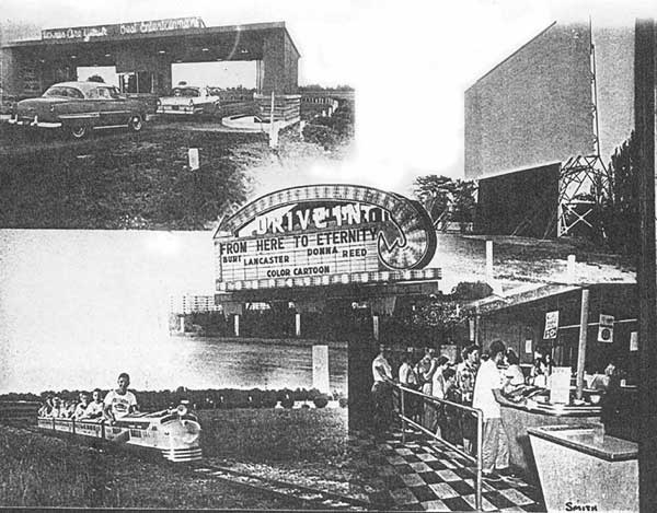
The Drive-In will surely bring back many memories for past Columbusites. The Drive In was located on Indianapolis Road (then 31A), and, as advertised, was one mile from town. Train rides for the kiddies, dusk to dawn movies, 4th of July fireworks, necking, and even church services were a part of our yesterdays...
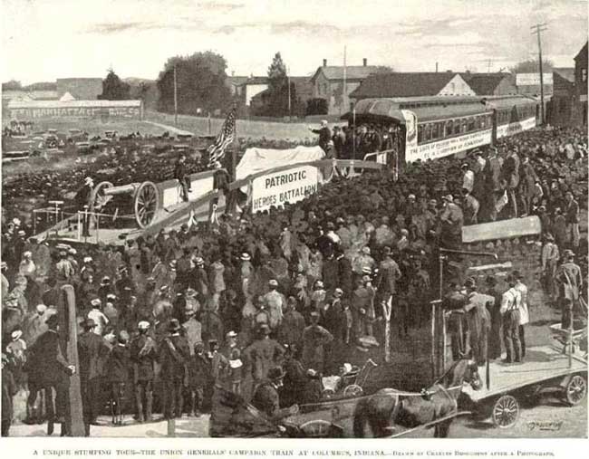
The photo of Civil War Columbus is the oldest picture I have found so far and shows Columbus in its infancy...
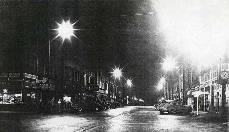
The downtown night photo taken sometime during the 1950's shows Washington Street from 5th Street south. Businesses such as H L Rost jewelers, Irwin Union Trust Company and Simmen Hardware can be seen under streetlights...
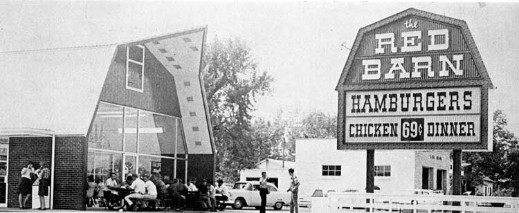
The Red Barn, located on 25th Street, was a hamburger joint whose specialty was the "Big Barney," similar to a Big Mac. It was close to Columbus High School (now known as Columbus North High School). Today, it's Mr. Lube...
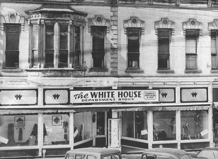
The White House was a popular clothing store, located on the west side of Washington Street between 4th and 5th Streets...
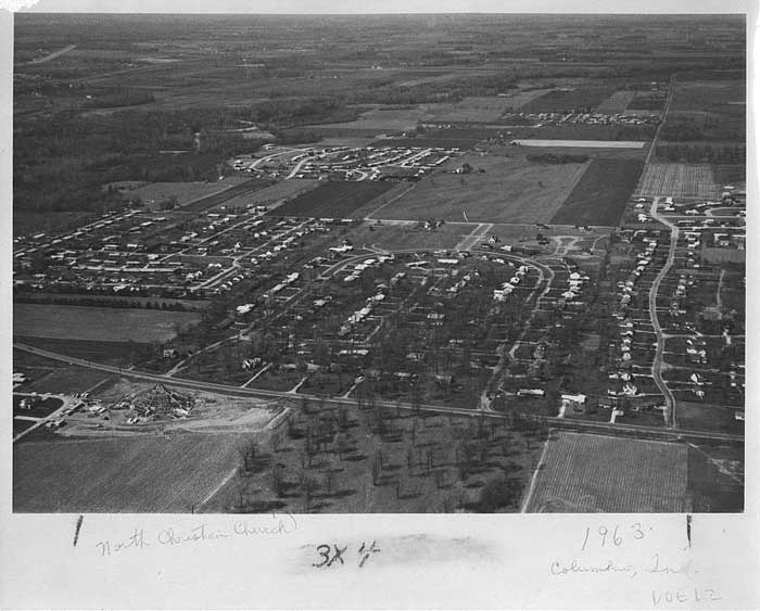
The 1963 aerial view of North Christian Church shows the church under construction, and gives the viewer a glimpse of how that part of Columbus has grown over the last 40 years...
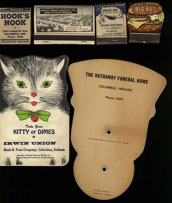
Advertising was as prevalent in the 1960's as it is today. Here's a sample of a few give-a-way items from Hook's Nook, Noblitt Sparks, Columbus Auto Supply, Frisch's, Irwin Union Bank and Trust, and Hathaway Funeral Home...
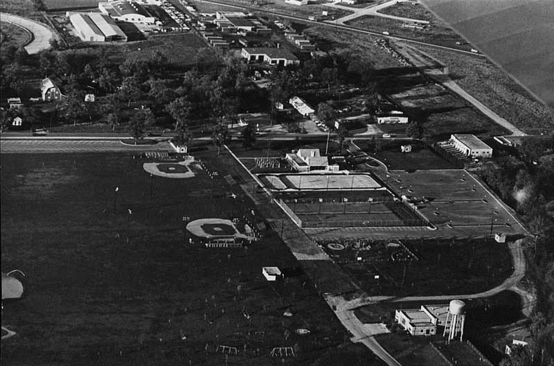
Another aerial photo: This time, Lincoln Center can be seen. The old 25th Street Fairgrounds (where Fair Oaks Mall is today) is to the left of the picture, and Eastbrook Plaza is nowhere to be seen...
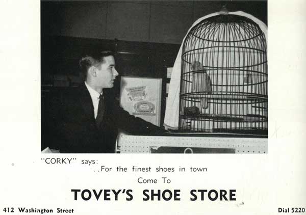
Any Columbus Indiana resident who bought shoes during the 1950's and 60's surely found their way into Tovey's Shoe Store (where Papa Harry's Deli is today). Corky the Parrott was a local attraction, as Poll Parrott shoes were a popular line at the time. Hey, you even got a free Poll Parrott clicker with each purchase of shoes!
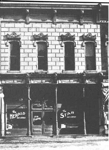
For the last two years, I have identified this picture as Cummins Bookstore. The reason I thought it was Cummins was the lettering on the front window. The Star, which I assumed was the Indianapolis Star newspaper, had as its agent George Cummins, thus the connection. I compared the picture with the building as it looks today, and came to the conclusion that it was, indeed, Cummins Bookstore. As it turns out, this isn't Cummins Bookstore at all. The address noted for this building is 225 Washington Street, which would put it across the street from the Courthouse.
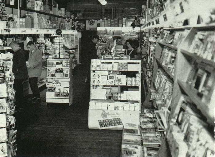
Cummins Bookstore at 406 Washington Street is the oldest, continually operated business in Columbus Indiana, and any resident or visitor to our city is encouraged to visit this historic place of business. Other than paint and inventory, the interior of Cummins Bookstore hasn't changed much since I was 12 years old (1964), and could be found on most Saturday afternoons contemplating which book or magazine would get the most of my 50 cent allowance. This picture does a great job of reminding the reader what it looked like in 1958. As you can judge from this picture, Cummins Bookstore had a little bit of everything, including "the room in the back," where the "nasties" of the day were kept safe from the inquisitive eyes of children. Today, the room in the back is comprised of computers and office equipment. I was proud to be associated with Cummins Bookstore during the time my brother owned it, and you could find me there almost every morning, sitting behind the counter, laboring over this website. My association with Cummins Bookstore gave me the opportunity to meet many people, from long-time residents to out of town visitors, but the people I enjoyed the most were those one-time residents who had moved away, were back in town for some reason or another, and just had to stop in and revisit a place from their past. Memories of the old place were different from person to person, but all shared the same wistful air about the eyes. For a history of Cummins Bookstore, click here.
|
City Map of Columbus Indiana, 1949
The White House Department Store
1963 Aerial View Construction of North Christian Church
The Herald and Star, 225 Washington Street
Cummins Bookstore Interior, 1958
|